
Public authorities / Digital transformation / Worldwide
Places, information and public services. Connected.
GIS viewers, asset inventories, AI copilots and bespoke applications for local and regional authorities, public bodies and infrastructure agencies. Turn scattered documents and field records into shared working tools.
Discuss your projectMUNICIPAL GIS / INVENTORY + DECISIONS
From recorded barriers to an inspection plan.
A local authority needs to know what to inspect, where to act and which evidence supports each decision. We connect geographic inventories, inspections and field teams in bespoke software, preserving the date and origin of each record.
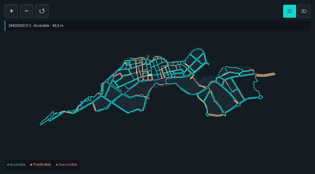
The case connects 1,203 pedestrian segments with kerb-ramp and barrier records across three study areas in Puerto de la Cruz. Inspect the original measurements, filter by mobility profile and prepare a review campaign with an assignee, date and scope.
Assessments retain their original inspection date. Inconsistent measurements are flagged for verification, not automatically converted into a compliance certificate.
Public-sector digital transformation / Practical applications
From records to decisions. From decisions to action.
Connect asset inventories, documents and calculations with the everyday work of a public authority. Each solution addresses a defined operational need, using traceable data and review by the responsible team.
01 / PUBLIC PROPERTYMunicipal property and rights registers
The asset and its records, together.
Connect land, buildings and concessions with titles, drawings, areas, valuations and maintenance. Review documentary discrepancies and prepare annual inventory updates from a shared record.
We build inventory-to-map checks, expiry alerts and investment scenarios. Area differences are flagged for review, never treated as automatic changes to ownership.
A statutory need in Spain
Articles 17 and 33 of the Local Authorities Property Regulations provide for an inventory and its annual correction. GIS supports this process; that legislation does not prescribe GIS technology.
Spanish local authority property framework02 / ACCESSIBILITYStreet maintenance and accessible routes
Prioritise interventions that reconnect a route.
Link pavement and crossing measurements, photographs and barriers with schools, health centres and public transport. Relate asset condition to the continuity of pedestrian routes.
Compare interventions, costs and available budgets to assess which works restore more connections. Every check retains its measurement, evidence and technical criterion.
A statutory need in Spain
Order TMA/851/2021 sets basic accessibility conditions for developed public spaces. Applicability depends on the intervention and relevant regime. A prioritisation score alone is not proof of compliance.
Spanish public-space accessibility conditions03 / INSPECTIONSAsbestos registers and inspection campaign planning
Turn territorial data into an actionable workload.
Separate preliminary detections, inspections and technical confirmations. Connect planning with team capacity, working days and budgets while retaining source provenance.
The Sabadell example uses public census-section aggregates: 1,522 candidate roofs across 110 records. Select sections, calculate a preliminary campaign and compare scenarios. It neither identifies individual buildings nor confirms asbestos.
Explore the planner with Sabadell dataA statutory need in Spain
Law 7/2022 requires a census and removal schedule. Its pre-2028 milestone concerns higher-risk public installations or sites, not every property.
Additional provision 1404 / PLANNING RECORDSTechnical records connected to the territory
One parcel. All its references.
Connect planning documents, revisions and technical records to a map. Staff can retrieve prior records and query an AI copilot with references to the original document and page.
Classification, access permissions, metadata and review workflows integrate with existing systems. Answers support professional review; they do not grant permits or issue administrative decisions.
A statutory need in Spain
Article 17 of Law 39/2015 provides for a single electronic archive of electronic documents from completed procedures. This is not a blanket requirement to scan every historical record.
Spanish electronic archive framework05 / DIGITAL TWINThe municipality in 3D. Decisions before action.
A territory you can query and simulate.
Integrate maps, terrain, buildings and BIM models with asset registers, records and interventions. Each element in the 3D environment can open its technical record, reveal its status and connect to its history.
We develop rehabilitation, maintenance and investment scenarios to compare alternatives, study impacts and visualise the sequence of interventions before construction.
Models connected to calculations
Depending on the available data and commissioned scope, we incorporate shadow and solar potential studies, accessibility analyses or hydraulic models. Results retain their assumptions and date; a 3D visualisation alone is not a validated simulation.
Connections to sensors, work orders and municipal systems are defined for each project, without requiring every existing tool to be replaced.
Explore buildings and shadows in 3DThese legal references concern Spain. Current legislation, regional rules and applicability are checked for each project. International services are adapted to the relevant jurisdiction.
Tell us which public-sector process needs to improveDigital transformation / Public sector
From obligations to working processes.
We structure technical records, connect applications and turn fragmented information into traceable workflows, integrating with the systems your authority already uses.
Technical records and electronic archives
Document classification, metadata, versions, permissions and review workflows ready to connect to existing records management systems.
Reusable public data
Clean asset inventories, APIs and geospatial connections, with publication requirements assessed for each dataset and jurisdiction.
Accessible applications and content
Keyboard navigation, accessible document structures and tested forms, supported by a documented review and remediation process.
For projects in Spain, relevant frameworks include RD 203/2021 on electronic administration and RD 1112/2018 on digital accessibility. These requirements are not automatically applicable to international projects. Scope, security, interoperability and acceptance evidence are defined for each authority.
Discuss a public-sector workflow2D and 3D GIS viewers
Explore infrastructure, networks, facilities, service areas and planned interventions through thematic layers, search, filters and linked asset records. An inventory can bring together location, characteristics, photographs, documents, inspections and incident history.
Where commissioned, GIS data can connect with BIM models and intervention sequences through agreed identifiers and coordinate references. Public layers and restricted operational information are separated. Data provenance, date and accuracy remain identifiable; a mapped location does not replace field verification.
Document inventories and internal AI copilots
Organize PDF projects, drawings, reports, manuals and technical records so that staff can find information with its supporting source. Answers can identify documents and pages, distinguish revisions and flag incomplete or conflicting evidence.
Access permissions apply to generated answers as well as original documents. The copilot supports staff and technical review; it does not independently issue administrative decisions or replace professional judgement.
Field applications for public assets and services
Record inspections, incidents, photographs, daily reports and interventions against buildings, lighting, water networks, roads, parks and other public assets. Each record can retain its location, author, date and review status.
Supervisors can follow assignments, outstanding actions and supporting evidence through views designed for each role. Offline capture, synchronization and maintenance-system integrations are specified and tested against the actual working conditions.
Public and internal platforms built to fit
Develop map portals, management tools, service dashboards and information interfaces around the work of each authority. Connect existing systems through authorized interfaces and agree exports, identifiers and update responsibilities.
Accessibility, keyboard use, mobile performance, hosting, permissions and ongoing maintenance form part of the agreed scope. Personal and restricted information is kept separate from material approved for public access.
Start with one service, area or asset group
Agree the process to improve, source information, users, integrations and acceptance criteria. Validate a pilot with the operational team before extending the solution to more departments or territories.
These digital transformation services are available to public authorities worldwide. Project languages, procurement conditions, hosting and applicable controls are defined with each organization. Preparing tender proposals for bidders is a separate service, offered in Spain only.
Your next project
What do you need to transform?
Share the available documents or describe the workflow. We will define the scope, information needed and review milestones.